Credit: Lewis Bernier, Direct Action Everywhere, used with permission
Identifying animal exploitation facilities is an important skill for activists, and the wide access to high quality satellite imagery databases like Google Maps has made this process extremely easy for anyone who puts in the time to learn some basic patterns.
While there are some changes from region to region, most animal “agriculture” facilities look generally the same, or at least have common aspects that make them easy to identify.
This document outlines the basics of identifying the following types of facilities on the West Coast of the United States. There may be slight variations when applying this to other areas.
- Dairy Farms/Feedlots/ “Beef” Farms
- Calf Raising Operations
- “Poultry” Farms
- Egg Farms
- Pig Farms
DAIRY FARMS/CATTLE FARMS/FEEDLOTS

37°31’23.5"N 120°46’42.0"W (Click here to see on map)
When identifying an intensive cow farm like a dairy or feedlot, there are a few characteristics that will jump out:
- Large areas of enclosed, well trodden dirt
- Large shade structures with no walls
- Often, human made manure lagoons
- Cows visible in the image
- “Milking Parlors” and milk processing barns
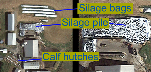
CALF RAISING OPERATIONS

37°31’05.8"N 120°45’03.0"W
Calf Raising Operations are usually easy to ID because they house calves in rows of outdoor “hutches”, as seen in the second picture. Look for these rows of crates, potentially alongside adult cows in feedlots and manure lagoons.
Note: In states that get extremely cold weather, calves may or may not be housed outside like this.
“POULTRY” FARMS
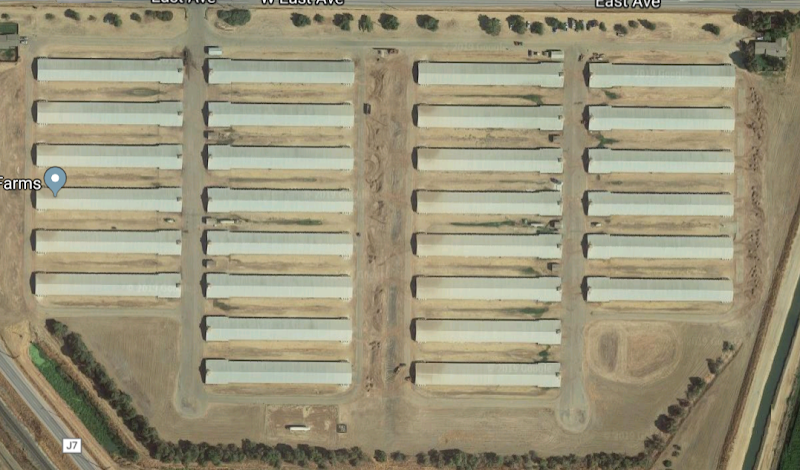
37°29’25.4"N 120°45’24.2"W (Click here to see it on the map)
While bird farms can easily be identified as such, it can be difficult or impossible to determine what species for birds are being raised, or potentially even whether it is a “poultry” or egg farm. Aspects that will tell you it is a “Poultry” farm include the following:
- Long rectangular barns
- Usually all barns on site are identical
- Barns are separated and not attached by any pipes or machinery
- No “Processing” building on site
- Usually no manure lagoon
EGG FARMS


37°30’05.9"N 120°43’49.9"W (Click here to see it on the map)
As mentioned above, it can be very difficult to be sure whether a farm is raising birds for their “meat” or their eggs, but there are some defining characteristics that will often give it away.
- Groupings of barns connected with enclosed conveyor belts
- Longer conveyor belts connecting groups of barns to each other
- Small admin buildings attached to each grouping of barns
- Larger processing buildings on each property
- Often with refrigerated trucks picking up eggs
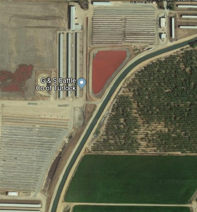
PIG FARMS

38°15’07.8"N 113°05’36.4"W (Click here to see it on the map)
To an untrained eye, pig farms can be very difficult to distinguish from “poultry” and egg farms, but there are a few factors that almost always set them apart. There are notable exceptions with extremely small scale pig farms, but for the most part these patterns hold true.
- Large, dark or red colored manure lagoons
- Groupings of long rectangular barns
- All barns connected with large walkways
- These are used to transport pigs from one barn to the next or to load them for transport
- Tanks of water and natural gas on one side of each barn
- Admin buildings connected to the walkways
Additionally, check this out this papertrail which shows examples of dead piles and compost piles discovered using satellite imagery.